《TAIPEI TIMES》TASA unveils high-resolution images from Formosat-8
對抗遺忘,是這個時代最艱難也最重要的事。
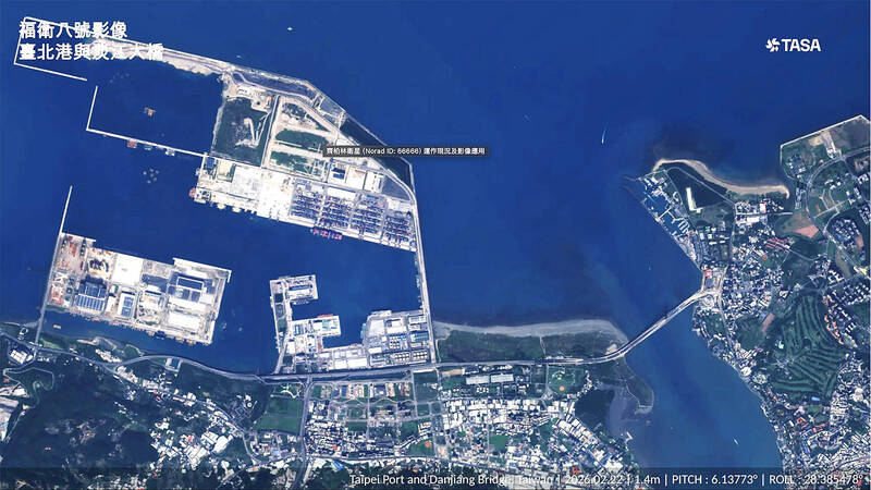
The Danjiang Bridge connecting New Taipei City’s Tamsui and Bali districts is pictured in a photograph taken by the Formosat-8 “Chi Po-lin” satellite and released yesterday. Photo courtesy of the Taiwan Space Agency
By Shelley Shan / Staff reporter The Taiwan Space Agency (TASA) yesterday unveiled high-resolution images of the newly opened Danjiang Bridge (淡江大橋) and the Port of Taipei (台北港) captured by one of Formosat-8’s satellites.
The photograph was shown during briefings presented by TASA and the National Science and Technology Council after a weekly Cabinet meeting.
Formosat-8 is Taiwan’s first domestically developed submeter resolution remote sensing satellite constellation, with the first satellite — named after the late Taiwanese documentarian Chi Po-lin (齊柏林) — launched into space in November last year.
The image quality of the sensor strictly complies with US military standards, with a signal-to-noise ratio that is far better than expected, TASA Director-General Wu Jong-shinn (吳宗信) said.
The agency has confirmed that 16 domestically developed components in the satellite have passed in-orbit verification and met their mission requirements, he said.
Once data collection is completed, the satellite would obtain flight heritage certification, demonstrating that domestic manufacturers can produce low-cost, high-performance, and internationally competitive satellite platforms and components, Wu said.
Satellite imaging is highly sensitive to chlorophyll content and the physiological condition of vegetation, he said.
“As such, it can be used in precision agriculture projects, enhancing the surveillance capabilities for forests, biodiversity and aquatic environments. It can also be used to observe the impact of sediment erosion on the Shihmen Reservoir [石門水庫], and is also being tested for net zero and carbon inventory applications,” he said.
The remaining satellites in the Formosat-8 constellation would be launched over the next few years, with the final satellite featuring a primary mirror with a diameter of 0.8m to 0.9m and aiming for an image quality of 30cm resolution, Wu said.
Taiwan would become one of the top 10 countries with indigenous optical satellite capabilities if the final satellite is launched in 2031, he said.
The raw image resolution has been verified as meeting the 1m specification since the satellite began capturing images in January, Premier Cho Jung-tai (卓榮泰) said, adding that the resolution could be further enhanced to 0.7m through post-processing.
In addition to capturing images in color, and black and white, the satellite is also capable of highest-resolution red-edge band imagery, enhancing environmental monitoring capabilities, he said.
The satellite, which is expected to officially begin operations in July, would be used for national security, environmental monitoring, precision agriculture, and disaster prevention and relief, Cho said.
新聞來源:TAIPEI TIMES